Remote Sensing with Safety and Compliance at the Core
Air. Land. Water.
"Compliant by design, Safe by default."
Providing Solutions Since 2017
Aeria Solutions delivers standardized, high-quality operational remote sensing across Canada using drones, ground, and surface vehicles. We bridge the gap between raw data and actionable insights, tackling complex challenges with rigorous compliance and uncompromising quality. Trust Aeria to handle your remote sensing needs reliably, reducing project risks and delivering peace of mind.


Flying past the competition
In the world of remote sensing, just collecting data isn't enough. Many providers treat it like a checkbox exercise, potentially compromising the safety, compliance, and quality essential for your success. Aeria Solutions flies past this standard. We deliver operational remote sensing where rigorous compliance, streamlined procedures, and uncompromising quality aren't afterthoughts—they're built into our core
ABOUT US
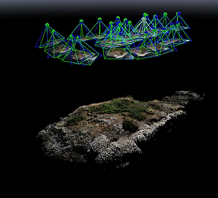
At Aeria Solutions we utilize advanced technology and remote sensing to offer creative solutions for a sustainable future. Our specialization in Lidar, Photogrammetry, Marine Mammal Monitoring allows us to provide valuable insights across multiple industries, especially in the resource sector. We prioritize advanced permissions and regulatory compliance, ensuring a strong focus on safety in all our operations.


Remote Sensing Solutions


Canada’s Trusted Drone Surveying Experts
Aeria Solutions is happy to provide cutting-edge Drone Services in Canada that increase efficiency and precision in your surveying and mapping needs. We specialize in high-quality drone surveys, providing accurate and dependable data to a wide range of sectors across Canada. Whether you require detailed aerial images, topographical maps, or real-time monitoring, our team of professionals is ready to provide unique solutions.
Professional Drone Survey in Alberta
When it comes to surveying in Alberta, Aeria Solutions stands out for its specialist Drone Survey services. Our drones are outfitted with cutting-edge technology, allowing us to take high-resolution photographs and data from even the most difficult terrains. Whether it's land development, infrastructure, or environmental monitoring, our drone services make surveying faster, safer, and more affordable.
Drone Services BC Wide
For clients in British Columbia, Drone Services from Aeria Solutions deliver unmatched precision in data collection. With our powerful drones and experienced operators, we are able to cover vast areas in a short period of time, ensuring that every detail is captured. From forestry and mining projects to real estate and agriculture, our Drone Survey services provide comprehensive insights that help drive informed decisions.
Why Choose Aeria Solutions?
-
Expertise: Years of experience in drone surveys across Alberta and BC.
-
Technology: Utilising the latest drone tech for maximum precision.
-
Efficient Service: Fast and accurate results with minimal downtime.
-
Affordable: Cost-effective solutions for your surveying needs.
Get in Touch with Aeria Solutions
Ready to experience the future of surveying? Contact Aeria Solutions today to discuss your Drone Services needs in Canada. Our team is here to guide you through every step of the process, ensuring your projects are completed with the highest level of accuracy and efficiency.